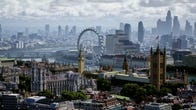
At the Google I/O 2022 keynote, CEO Sundar Pichai debuted a new feature coming to Google Maps that gives users a drone-level aerial view of cities, offering a helpful middle ground between satellite and street views.
Immersive View, as the new mode is called, uses “billions of photos” to model buildings and trees in 3D using machine learning. The new view lets users understand a city’s topography, rotate their perspective to look between buildings, and see traffic and weather in real time.
Immersive View also gives 3D looks into nearby restaurants, allowing users to scan around and rotate their view to get a get a better look at the layout, which may be important for those still cautious about eating indoors.
Immersive View is created from neural rendering based on photos alone and is streamed from Google Cloud, so it will run on any smartphone. The new view will start rolling out in Google Maps for select cities globally this year.
Watch this: Google Maps Immersive View Reveals Building Interiors
1:25