Google is using AI to create augmented reality maps of the world that you can navigate before you actually go there, and it’s creating more detailed maps for cars and EVs
4 hours ago
 –>
–> 
–>
This week, Google introduced a collection of AI-powered improvement to Maps in order to make it easier to use, to provide more information, and to give users a much more detailed view of the location they’re headed to.
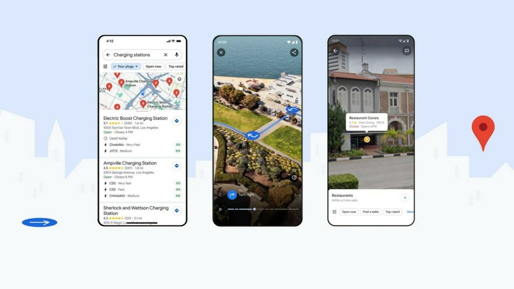
Perhaps the most impressive new toys to play with will be Immersive View for routes, and Lens. These features give users complete pictures of how to get to a destination, and what it will look like once they get there.
Immersive View gives you a 3D view of your route to look at before you head out. It provides turn-by-turn directions, and a drone’s eye view of the drive. It can also simulate things like traffic and weather patterns to give you an accurate idea of what you’re likely to encounter on your journey.
advertisement scroll to continue
Read: Google’s AI Traffic Lights Are Reducing Traffic Stops By 30% And Emissions By 10%
The function builds on Immersive View for places, which stitches billions of Street View and aerial images together using AI to create a photorealistic 3D image of an area. This feature is rolling out to a limited number of place at first, including Amsterdam, Barcelona, Dublin, Florence, Las Vegas, London, Los Angeles, Miami, New York, Paris, San Francisco, San Jose, Seattle, Tokyo and Venice.
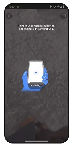
If you want to know what your destination looks like, and what’s there, Lens in Maps creates an augmented reality version of your destination. Google suggests that this will be helpful for people who are going to a new place and need help navigating things such as a subway station, or finding hidden gems in a new location. This feature is coming to 50 new cities, including Austin, Las Vegas, Sao Paulo, and Taipei.
On the less technically impressive (but likely more useful) side of the equation, Google is adding greater detail to its normal routing function. Maps now shows more buildings to help drivers orient themselves, and will have better lane details to help on highways. In addition, it’s updating the colors it uses to make it easier to read.
In the U.S. drivers will soon be able to see if there is an HOV lane on the way to their destination. In Europe, Google says that it is using AI to provide better information about speed limits.
For EV drivers, vehicles equipped with Google built-in will have more in depth information about charging locations. In addition to knowing what plugs your vehicle is compatible with, Maps will also tell drivers what kind of charger (fast or slow) they are headed towards. It will also use information gathered about charger usage to tell drivers which charging ports are likely to be broken, and which ones are good.
Finally, if you’re in a new place and need to find something to do, Maps’ search function can now find more things. For instance, if you search something like best place to find “animal latte art,” it will offer results with photos from its users to help you find exactly what you’re looking for. In addition, its results for searches like “things to do in” whatever city will offer better suggestions that are inspired by the place.


